Back

De Standaard – Map of Brussels restructure plan
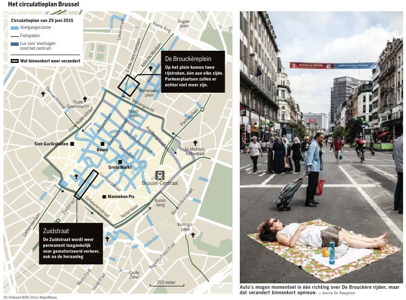
The image is a collage displaying a map of Brussels restructure plan and a photo street view of the city on the right. The map, titled “Het circulatieplan Brussel” (The Circulation Plan Brussels), reveals the circular road plan from 2015 and marks several prominent locations and streets such as De Brouckereplein and Zuidstraat with text boxes.
These two text boxes, accompanied by black rectangles, represent areas that will undergo changes soon. For De Bouckèreplein this means there will be two driving lanes on the square, one on each side. There will no longer be any parking places. For Zuidstraat the changes are that the street will permanently be accessible for motorized vehicles, even after the reconstruction.
Other markings on the map are pedestrian zones, marked with light blue lines, bike lanes marked with green lines and a dark blue line was added for loops around the city center for vehicles.
POI’s in het area include Grote Markt, Manneken Pis, Oude Graanmarkt, Sint-Gorikshallen, Brussel Central Station, St-Michiels Cathedral and more. Some street names that are included on the map are Grasmarkt, Cellebroerstraat, Gote Zavel, Pachecolaan and Zuidstraat among others.
In the bottom right a scale bar can be found indicating 250 meters.
Similar Data visualization maps