Back

Associated Press – Israeli military forces inside Gaza
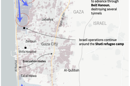
The image is a geographically detailed map providing insights into the conflict between Israeli forces and Hamas fighters, across various locations including Gaza City, Beit Hanoun, Zeitoun, and Jabaliya.
Key operations and developments, such as Israeli forces advancing into Beit Hanoun, Hamas fighters engaging with Israeli forces, and ongoing Israeli operations around the Shati refugee camp, are highlighted with labels and arrows. An ‘evacuation border’ and routes are indicated, suggesting measures for civilian safety.
Israel troop advances, significant fighting in the past 24 hours and the damage from October 7th – November 5th are highlighted on the map using different colors and patterns.
The map also includes a scale for reference and has an inset map in the top right corner to specify the location of the dispute.
Similar Data visualization maps