With Hurricane season just around the corner, we are here to help you remain proactive in providing the most accurate and up-to-date information. With access to the most recent Hurricane data sourced from the National Hurricane Center (NHC) and the National Oceanic and Atmospheric Administration (NOAA), you have the opportunity to play a crucial role in delivering timely and precise updates during critical events. Mapping the Hurricane season has never been easier.
Being a Live Data Layer, it is continuously updated every 60 minutes, showcasing the latest forecasts, both in the tool and in any interactive output you create. Interactive maps allow you to generate an automatic widget, always displaying the latest real-time information to deliver accurate coverage and keep your audience informed.
Access to real-time data
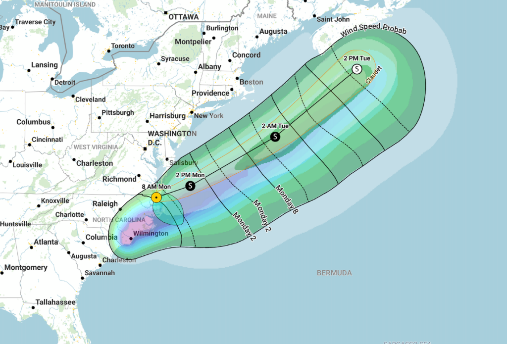
Our Hurricane Live Data Layer provides our users with accurate information and real time updates on the Hurricanes, including: likely arrival time, earliest arrival time, windspeed, initial wind extent, forecast track, track cone and of course the storm name. With this information, you can focus on accessing the most recent evacuation orders and mark the (already or assumed to be) affected areas for your reportings.
Reliable, accurate and trustworthy
Live Data Layers allow you to provide reliable and accurate reporting during times of crisis. Broadcasters and newsrooms can access real-time Hurricane data to incorporate into their publishings, adding geographic context to their news features. Rely on Mapcreator’s Live Data Layers and forever avoid misinformation or speculation, always providing your audience with trustworthy information.
Customize
You decide what to show. Navigate to the elements list to hide or show certain parts of the Hurricane Live Data Layer or base data of your map. Change your zoom or detail level and ensure all important information is visible. Do you want to take it even further? Contact our team to get a custom style of the Hurricane data layer implementing your own branding. Customizable elements include:
- Forecast Track Symbol
- Forecast Track
- Track Cone
- Storm Name label
- Likely Arrival Time label
- Earliest Arrival Time Labels
Download an iframe
Export your project as an interactive Web Map and embed this Live Data Layer on your website through an iframe. Just like the Live Data Layer in the Mapcreator tool, the embed published on your website will continuously and automatically update every 60 minutes as the most accurate Hurricane data comes in. Try it out in the example below – and don’t worry if nothing appears on the map, it simply means there are no current Hurricanes.
Try it out now
The integration of Live Data Layers into coverages has revolutionized the way newsrooms report and respond to critical world events. Provide valuable insights during the Hurricane season by delivering accurate reports and easy to read visualizations.
With Mapcreator, you can play a critical part in helping inform the public, as well as preparing, responding and recovering from the devastating effects that Hurricanes can have. Don’t waste any time and start mapping now!