"Avec seulement deux graphistes en interne et une demande croissante de cartes détaillées pour nos reportages, nous devions trouver une solution cartographique intuitive utilisable par les producteurs eux-mêmes."
Kim Colombero
Directeur artistique chez Action News Jacksonville
En savoir plus
"KSHB l’utilise presque quotidiennement. C’est à la fois simple et puissant. Les modèles que vous avez créés offrent un rendu net en diffusion et sur le numérique. Cela fait 10 ans que je travaille chez Scripps et c’est le meilleur programme de création de cartes que j’aie vu."
Matt Howard
Producteur principal chez KSHB-TV
"Mapcreator nous facilite vraiment la vie quotidienne dans la production de journaux."
Julia Oberle
Designer média chez Main-Echo
En savoir plus
"Une chose que je dois souligner : votre service est excellent ! Super rapide, compétent et vraiment convivial !"
Jürgen Runo
Infographiste chez Braunschweiger Zeitung
En savoir plus
"Mapcreator est un outil polyvalent et facile à utiliser qui permet de créer des cartes pour raconter des histoires sans avoir besoin d'être expert en code ou en programmation."
Jorge Cortés
Journaliste infographiste, professeur à la Design School de l'Université catholique du Chili et directeur de l'agence Gráfica Interactiva
"Mapcreator est un outil hautement recommandé pour universaliser l'utilisation de la géolocalisation de contenu dans une salle de rédaction : interface utilisateur intuitive, courbe d'apprentissage rapide, agile, facile à publier et adaptable à tout support de diffusion (imprimé/ordinateur/mobile)."
Rafael Höhr
Éditeur graphique chez Prodigioso Volcan
"Depuis que notre équipe a commencé à utiliser Mapcreator, nous avons pu produire des cartes plus rapidement. Nous trouvons ce logiciel très efficace et très facile à utiliser. L’équipe de Mapcreator est toujours rapide pour répondre aux demandes et ils s’efforcent constamment d’améliorer leur outil pour nous. Leur niveau de service est supérieur."
Karl Gelles
Designer chez USA TODAY
"C’est une équipe extrêmement dévouée, qui améliore constamment ses produits pour s’assurer qu’ils répondent exactement aux besoins des clients via leur outil."
Steve Bernard
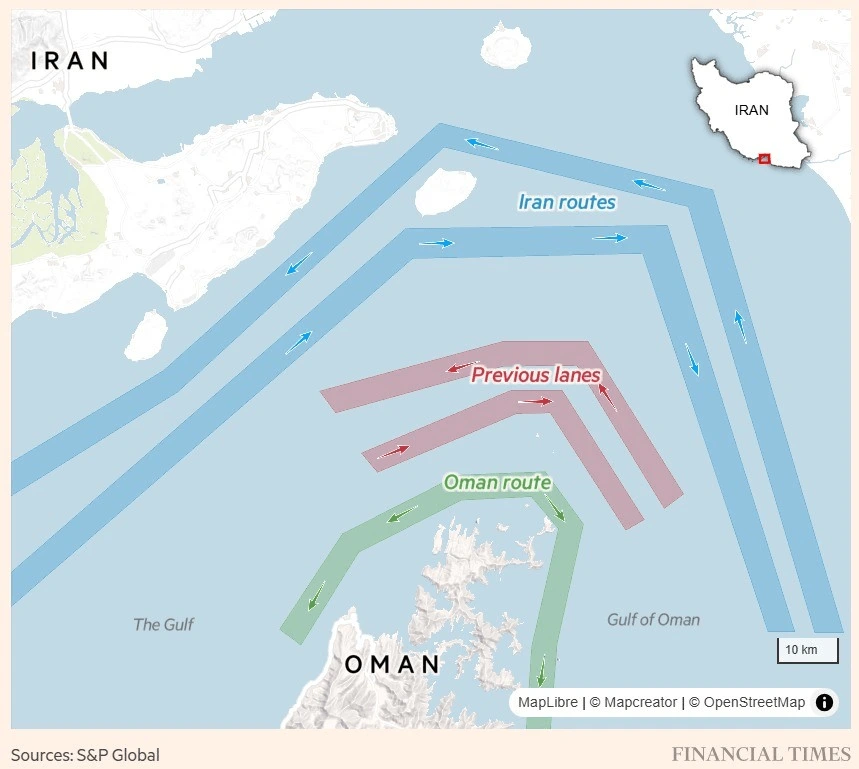
Journaliste visuel senior au Financial Times
"Disposer d'un outil comme Mapcreator nous permet d'obtenir des cartes de pointe sans avoir de cartographe ou de spécialiste graphique en interne. Nous sommes passés de l'absence de cartographie dans nos journaux et sur nos sites web à l'utilisation de plus de 100 cartes dans bon nombre de nos publications l'année dernière. Cela n'aurait pas été possible sans Mapcreator."
Jon Wile
Vice-président Contenu chez American City Business Journals
"L'une de nos équipes graphiques consacrait auparavant une journée par semaine uniquement à la création de cartes. Elle traite désormais les demandes de cartes à la volée et obtient un style cohérent dans l'ensemble de son travail."
Danny Wilkins
Directeur de la technologie pour les rédactions du Times, du Sunday Times et du Sun
En savoir plus